If you've been counting the days until the deep winter chill finally eases its grip, there's a glimmer of good news: temperatures are indeed about to rise across Spain. But, as often happens, that milder air is arriving with a bit of a sting in its tail.
Storm Goretti: Spain Braces for Impact! Is This th...
That's right, Spain is bracing itself for Storm Goretti. Aemet, the state meteorological agency, is warning of a volatile mix of strong winds, heavy rain in some regions, and snow in the mountains. Several communities are already on alert, which, let's be honest, makes this one of those weeks where the weather forecast dominates every cafe conversation.
Starting Thursday, January 8th, a general rise in temperatures will be noticeable across the mainland and the Balearic Islands. The most significant jump will be felt overnight. Finally, those minimum temperatures are set to lift after what feels like an eternity of freezing mornings. Frost will become increasingly limited to higher inland areas and the Pyrenees, where, admittedly, some moderate freezing conditions may still linger. I know my citrus trees in Valencia will certainly appreciate the break!
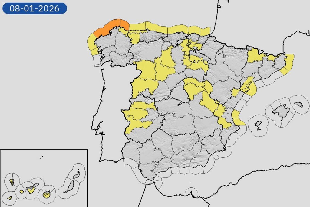
Concurrently, a pretty significant 18 provinces have activated weather warnings, a clear sign that Goretti isn't arriving quietly. Wind is poised to be the dominant feature of this weather shift. Aemet is warning of very strong gusts in Galicia, along the Cantabrian coast, and across mountain areas in the northern third of the country. And it's not just the north; exposed inland areas along the eastern side of the peninsula and parts of the Mediterranean coast could also feel the brunt.
The sea isn't escaping unscathed either. Significant waves are expected along much of the northern coastline, with an orange warning active on parts of the A Coruña coast and yellow alerts elsewhere along the Cantabrian and Mediterranean shores. Coastal walks, fishing trips, and small boat outings? Maybe best to reconsider those plans for now.
While none of this is particularly *unusual* for winter, the timing – arriving just as the cold is supposed to ease – could definitely catch people off guard. A mild day doesn't necessarily mean calm weather, folks! As the fronts linked to Goretti move across the country, rain will arrive first in the northwest, and once again Galicia looks set to take the biggest hit. Persistent and locally heavy rainfall is expected, particularly in the western half of the region, where wet spells could last for hours. So, pack your umbrellas (and maybe a sturdy raincoat, just in case).
Snow hasn’t disappeared entirely – it’s simply being pushed uphill. As temperatures rise, the snow line will climb steadily. In the northern mountains, it will initially sit between 1,400 and 1,600 meters, rising towards 1,800 to 2,200 meters by the weekend. The western Pyrenees could see some pretty decent accumulations at altitude, while other ranges will mostly keep snow restricted to the highest peaks.
For ski resorts, this could be a bit of a mixed bag. Higher slopes might benefit from the fresh snowfall, but lower areas will increasingly see rain rather than snow. So, check conditions carefully before you head out.
Looking ahead to the weekend, the atmosphere *should* calm slightly – but only slightly. Saturday, January 10th, is predicted to bring a modest improvement, moving from southwest to northeast, although…
Comments
Please sign in with Google to post a comment
No comments yet. Be the first to comment!