Spain is bracing itself for potentially chaotic weather as a series of Atlantic fronts are set to converge, threatening widespread rainfall and a possible DANA (isolated high-altitude depression). The State Meteorological Agency (AEMET) has issued alerts, and while we've seen some rain already, it looks like the worst might be yet to come.
Spain Braces for DANA Onslaught: Is Chaos Inevitab...
After a relatively mild start to January, things are definitely taking a turn. AEMET confirms that these Atlantic fronts will sweep across the Iberian Peninsula, bringing rain from west to east. Think of it as a slow-motion weather system freight train heading our way.
But here's where things get interesting. Weather commentator Jorge Rey is warning about a potential DANA arriving next week. If you're not familiar, a DANA can be a real headache, unleashing intense storms and snowfall that can disrupt travel and daily life. We're talking potential for significant disruption across several regions. Remembering Storm Filomena, it's easy to see why people are paying attention.
This week is already looking unsettled. The initial Atlantic front is bringing rain to western Spain, and a low-pressure system on Friday will likely spread the wet weather across much of the country. Snowfall is expected, primarily in the mountains, but forecasters say accumulations will be limited… at least for now. The key here is that the situation is fluid, and changing air masses could quickly lower those snow levels. It's a waiting game.
Looking ahead, Rey believes a more dramatic shift is on the horizon. In a recent YouTube video, he claims a new weather system is forming, potentially bringing polar maritime air, increased humidity, and generally unstable conditions to Spain next week. Think shivering and damp. Not a great combo.
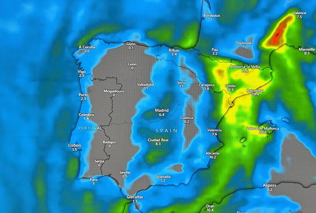
According to Rey, this could mean strong storms and heavier snowfall, especially from midweek onwards. He suggests that Thursday will see a noticeable increase in snowfall, particularly in inland areas like Soria, as well as higher elevations in Granada. He also anticipates intensified rainfall in regions like Catalonia and Valencia. Essentially, if the DANA develops as predicted, we could be in for a prolonged period of seriously wet and wintry weather.
It's worth noting that Rey isn't a certified meteorologist, but he's become quite popular, particularly after his accurate prediction of Storm Filomena back in 2021. While experts stress the importance of sticking to scientific forecasting, Rey's warnings often align with AEMET's, as they seem to be doing now, which understandably amplifies public interest. And frankly, after Filomena, you can't blame people for wanting to be prepared.
So, what should you expect? Maximum temperatures are forecast to remain below 10°C across much of the country, with milder conditions largely confined to coastal areas. Inland regions, especially in the north and central parts of the peninsula, could see even colder temperatures. Keep an eye on the forecast and prepare for potential disruptions – it looks like winter is finally here, and it's not messing around.
Comments
Please sign in with Google to post a comment
No comments yet. Be the first to comment!