Big news for Earth scientists! NASA's Satellite Data Explorer (SDX) just got a serious upgrade, thanks to the addition of Vantor's Precision3D terrain models. If you're like me, you might not spend your evenings dreaming about digital elevation models, but trust me, this is a significant development. Think of it as giving researchers a much clearer, more detailed picture of our planet's surface, both what's on it and what's underneath.
Satellite Data Breakthrough! New 3D Terrain Models...
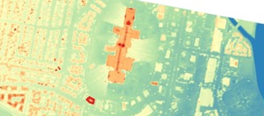
The update, facilitated through NASA’s Commercial Satellite Data Acquisition (CSDA) Program, brings three key products from Vantor into the fold: a Digital Surface Model (DSM) with a 1-meter resolution, a Digital Terrain Model (DTM) also at 1-meter resolution, and an Elevation Bundle that combines both at various resolutions. In layman's terms, the DSM captures everything on the surface – buildings, trees, even cars. The DTM, on the other hand, strips all that away to show the bare earth. Together, they offer a powerful combination for understanding our planet.
What makes this particularly exciting is the level of detail we're talking about. A 1-meter resolution means that for every square meter on the ground, the model captures an elevation data point. This kind of precision is crucial for a wide range of applications, from urban planning and environmental monitoring to disaster response. Imagine being able to model potential flood zones with far greater accuracy, or precisely map terrain for infrastructure projects. That's the power this data unlocks.
Dana Ostrenga, Project Manager for the CSDA, sums it up nicely: "Digital Elevation Models are foundational geospatial infrastructure for NASA’s science community." She highlights how this addition ensures consistent access to high-quality terrain data, which ultimately sharpens geometric accuracy and supports crucial modeling efforts. It’s all about better understanding our planet and being able to respond more effectively to its challenges. This isn't just about pretty maps, it's about actionable insights.
Accessing this wealth of data is also relatively straightforward. Researchers can use their existing Earthdata Login to search, discover, and download the Vantor data through the SDX tool, once they've navigated the necessary approval process and signed the end-user license agreement. It’s a small price to pay for the potential impact this data could have on their research. The CSDA program’s mission is to harness commercial satellite data for the advancement of Earth System Science, and with this latest addition, they’re taking a big step in that direction. I, for one, am eager to see what discoveries this new resource will enable.
Comments
Please sign in with Google to post a comment
No comments yet. Be the first to comment!