Spain's had a taste of spring, a glorious, fleeting glimpse of warmer days. But hold on to your hats, folks, because winter’s staging a comeback! After basking in some truly unseasonably warm weather, especially up along the Cantabrian coast, we’re staring down the barrel of a serious temperature plunge this weekend. And if that wasn’t enough, brace yourselves for a visit from our old friend, Saharan dust, and whispers of a potential DANA – that's an isolated high-level depression, for those not fluent in weather-speak – swirling our way early next week.
Spain Weather ALERT: Shocking Plunge! Dust, DANA, ...
Seriously, if you’ve already swapped out your winter wardrobe, time to dig out those heavier layers. I, for one, am not ready to face icy mornings again.
According to the latest forecasts from Aemet (Spain’s state meteorological agency) and reliable weather platforms like eltiempo.es and Meteored, the atmospheric shift begins today, Friday, February 27th. An Atlantic front is muscling its way in from the northwest, bringing cooler temperatures and generally grumpier weather conditions.
The northwest will feel it first. Think Galicia, Asturias, Cantabria, and the northern bits of Castilla y León. Expect increasing cloud cover and a definite chill in the air, with daytime temperatures struggling to climb above 12°C to 16°C. Not exactly beach weather, is it?
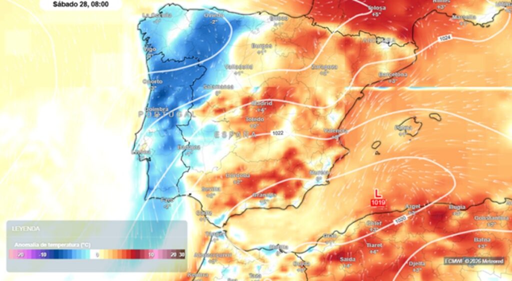
By Saturday, the cooler air will have spread its reach further south. A large chunk of northern Spain and the inland areas can anticipate maximum temperatures hovering between a chilly 10°C and 15°C. This is particularly true for the Cantabrian region, the northern plateau, Navarra, La Rioja, and Aragón. Shivers!
But wait, there's more! Adding to the overall gloom, the dreaded "calima," that Saharan dust haze, is making an early appearance this year. Seems a low-pressure system kicking around over the Sahara is about to blow plumes of dust towards mainland Spain, the Balearic Islands, and even the Canary Islands. Imagine waking up to a Mars-like landscape.
The meteorologists at Meteored are warning that this first significant dust intrusion of the year will primarily blanket the southeast of the peninsula, along with the Balearics, Ceuta, and Melilla. Expect hazy skies, reduced visibility, and that distinctive orange-grey hue in the atmosphere. And if rain happens to coincide with the dust cloud? Well, prepare for muddy showers that will leave your car and patio furniture sporting a lovely reddish-brown coating. Fun times.
Down in the Canary Islands, a nearby DANA is promising showers, particularly affecting the eastern islands. It’ll also bring a noticeably cooler feel. So much for eternal sunshine.
And the nights? Get ready for a sharp drop in temperatures inland, with frost making a comeback in parts of Castilla y León and other interior regions. Think icy windscreens early on Saturday morning.
Looking ahead to early next week, weather models are hinting at the potential formation of another DANA between Monday and Tuesday, triggered by a trough detaching over the western side of the peninsula. The details are still fuzzy, but it could mean this unsettled weather pattern sticks around for a while longer.
So, the bottom line? Spain's springtime tease is officially over. After those blissful days of almost unnatural warmth, coats, umbrellas, and maybe even those long-forgotten ice scrapers might be essentials once again. It's a stark reminder that winter hasn't quite packed its bags yet. Stay warm out there!
Comments
Please sign in with Google to post a comment
No comments yet. Be the first to comment!