Spain is about to get a stark reminder that winter isn't quite done with us yet. After a brief respite, forecasters are predicting a significant dip in temperatures accompanied by rain, wind, and the return of snow to some lower elevations. It looks like the polar jet stream is about to make its presence felt across the Iberian Peninsula.
Spain on FREEZE Alert! Polar Jet to Unleash ARCTIC...
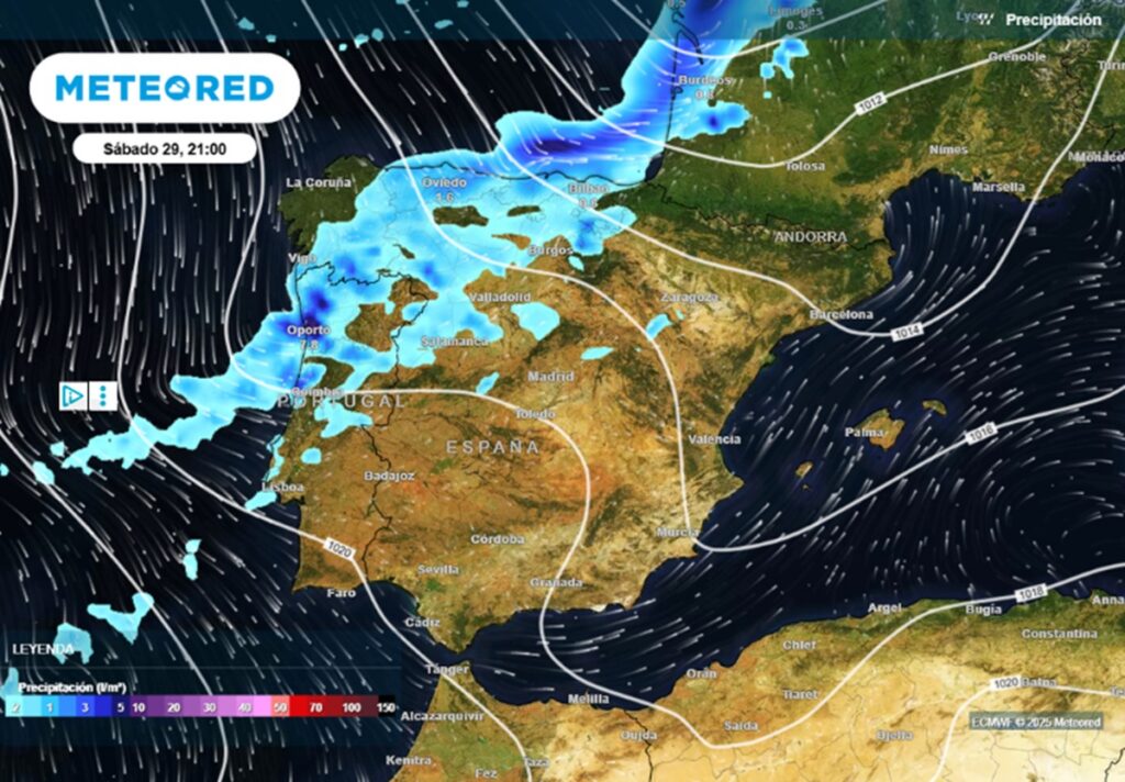
The change is expected to begin overnight, morphing into Saturday. Galicia will be the first to feel the effects as a weather front pushes in, bringing with it an initial wave of rain. However, the main event arrives early Saturday: a colder front surging in from the northwest. Expect more intense rainfall, especially along the Atlantic coastline. I've seen these fronts move in before, and they can be pretty dramatic, especially if you're near the coast.
This band of rain isn't content to stay put; it's going to gradually spread inland throughout Saturday. It will hit Extremadura, Castilla y León, Asturias, and Cantabria before making its way to the Basque Country, Navarra, La Rioja, Madrid, and Castilla-La Mancha by the end of the day. Basically, a large chunk of the country is going to see some rain on Saturday.
While minimum temperatures might actually creep up slightly in the northwest and southeast (thanks to cloud cover and wind), the rest of Spain should brace for a continuation of the chilly conditions we've been experiencing. The slight temperature rise is the silver lining for some, but let's be real, it's still going to be cold.
By Sunday, the front will continue its eastward march, spreading rain—albeit lighter rain—across Andalucía, Murcia, the Valencian Community, the Balearics, Catalonia, and Aragón. But the real story on Sunday is the return of snow to lower altitudes. This means the arrival of true winter conditions for many of the mountainous regions across the country. We're not talking about widespread blizzards, but showers are expected to be most persistent and intense in the east and the Basque region, gradually easing off elsewhere. Time to dust off those snow boots, folks!
Sunday also brings a bit of a temperature seesaw. Minimums are expected to rise in many inland areas because of the increased cloud cover and stronger winds. This will help limit frost, which is good news for those of us who hate scraping ice off our car windshields. However, maximum temperatures are forecast to fall almost everywhere, dropping between 2 and 4 degrees Celsius. So, a slightly warmer night, but a colder day.
The Canary Islands, as is often the case, look set to remain relatively unaffected by the mainland's weather woes. Stable conditions are expected, with just a slight chance of showers on the northern slopes of the mountainous islands. Lucky them!
All in all, forecasting models suggest Spain is heading into December with a pretty classic winter pattern. Active, changeable, and definitely not boring. It's shaping up to be a weekend where staying indoors with a warm drink might just be the best option.
Comments
Please sign in with Google to post a comment
No comments yet. Be the first to comment!